Rural adjective, of or relating to the country, country people or life, or agriculture.
Given the diverse perspectives on rural places, it is not surprising that the U.S. government does not have a standard definition of rural. From a policy perspective, rural is defined as the area not otherwise classified. The federal government prescribes how urban places are to be defined, so that rural is “everything else.”
Urban regions are defined in one of three ways:
- based upon land use
- administratively
- economically
Respectively, the Federal government labels these places as incorporated places, urban and combined or metropolitan statistical areas. While federal agencies will use a variety of metrics to qualify regions for specific programs, official definitions of urban places are determined by the Census Bureau and the White House’s Office of Management and Budget (OMB). The Census Bureau defines urban areas as regions containing at least 2,500 people, where at least 1,500 of which reside outside of institutional group quarters (such as college dorms or jails). Areas not meeting this definition are rural by the Census Bureau. OMB defines metropolitan areas based upon economic interactions; a metropolitan statistical area is one that contains a core city with a population of at least 50,000 and conjoining counties that are economically connected (generally defined by commuting patterns) with the core city. Areas outside of those nonmetropolitan. Administrative jurisdictions, such as city boundaries and incorporation limits, are often determined by each state and are commonly used to differentiate between urban and rural residents.
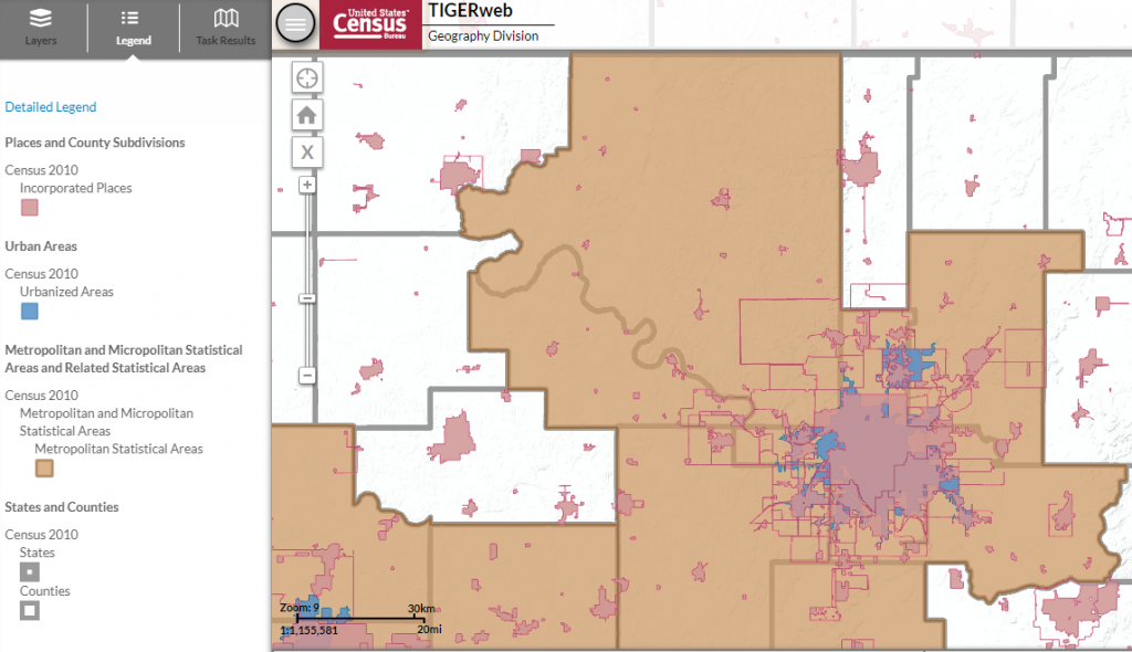
The map of Tulsa, Oklahoma above illustrates how the definition of rural varies. The pink areas represent the municipal jurisdictions of Tulsa (the largest pink area) and the surrounding cities that comprise the region of Tulsa; anything outside of these pink areas is unincorporated space, which is sometimes deemed rural. The blue areas represent the urbanized areas within Tulsa and surround cities; since these are based upon population counties within Census tracts, one can find ‘rural’ places even within the city limits of Tulsa (those places which are pink but not also blue). Finally, the tan region represents the Tulsa, Oklahoma metropolitan statistical area, and the white, nonmetropolitan areas represent ‘rural’ by this definition.
The Census Bureau, conveniently, provides demographic data for each of these three characterizations of rural: incorporated places, urban areas, and metropolitan statistical areas. The table below presents the share of U.S. population classified as rural for each of these characterizations in 2010.
| Region | Urban | Rural | Share Urban | Share Rural |
| US = 308,745,538 | ||||
| Metro | 263,096,669 | 45,648,869 | 85.2% | 14.8% |
| Urban Areas | 249,253,271 | 59,492,267 | 80.7% | 19.3% |
| Place | 192,144,185 | 116,601,353 | 62.2% | 37.8% |
One can see that the share of rural residents more than doubles depending on which characterization is used. Based upon metropolitan statistical areas, only 1 in 7 Americans live in rural places. However, using administrative boundaries, 2 in 5 Americans are rural residents.
As the above map and chart highlight, how rural is defined dramatically changes who is included in rural areas. Many federal programs rely on the dichotomous definitions discussed here to establish eligibility criteria, so which individuals and/or communities (can) benefit from these programs is largely determined by these policies. Some federal agencies, such as USDA Rural Development, have established alternative eligibility criteria with the hope of better targeting their programs to the intended rural audience; however, these additional criteria also create confusion over what is and is not rural.
The Office of Management and Budget sets the standards for designation as a metropolitan statistical area, and this office recently proposed changing the minimum population threshold from 50,000 to 100,000 in the urban area. The implication of this change, based upon 2010 Census data, is a reclassification of 144 metropolitan statistical areas as nonmetropolitan, meaning that nearly 19 million additional people would be counted as rural in the calculations above. Using this new threshold would increase the rural share of population to 21 percent. As with any policy change, there will be winners and losers that result. Total federal funding to metropolitan areas would likely decrease, since this allocated directly to the MSA based upon population; fewer MSAs would likely mean fewer dollars disbursed. However, rural funding is often competitively allocated, so that increasing the number of regions competing for funding means it will likely be harder for certain rural communities to receive federal funding.
One particularly desirable alternative to the current binary system is to use multiple categories and reflect the diversity that exists across space. In the 1990s and 2000s, USDA Economic Research Service developed several classification systems that provided greater variation in regions. The Rural-Urban Continuum and Urban Influence Codes, for instance, classify counties into categories based upon population and proximity. The ERS Typology Codes provide insight into the variation in the industrial composition of counties classified as nonmetropolitan. Such a definition scheme could provide a greater understanding of the diversity that exists in rural places as well as better target federal resources to the appropriate audiences.